![](/images/other/stat-length.png)
![Trail Walking Le Dévoluy - Tête de Garnesier.Devoluy.(30-10-16) - Photo](https://media.geolcdn.com/t/1900/400/ext.pjpeg?maxdim=2&url=https%3A%2F%2Fservices.sitytrail.com%2FGeolivesWS%2FDownloadMedia.ashx%3FTrailID%3D653042%26Media%3Dfix__20161030082556.jpg)
Tête de Garnesier.Devoluy.(30-10-16)
Dervalmarc
User
![Length](/images/other/stat-length.png)
Length
12.6 km
![Max alt](https://static1.geolcdn.com/siteimages/upload/files/1508320355ic_sort_altitude_max_24dp.png)
Max alt
2335 m
![Uphill gradient](https://static1.geolcdn.com/siteimages/upload/files/1508320355ic_sort_den_pos_24dp.png)
Uphill gradient
1103 m
![Km-Effort](/images/other/stat-length.png)
Km-Effort
27 km
![Min alt](https://static1.geolcdn.com/siteimages/upload/files/1508320355ic_sort_altitude_min_24dp.png)
Min alt
1240 m
![Downhill gradient](https://static1.geolcdn.com/siteimages/upload/files/1508320355ic_sort_den_neg_24dp.png)
Downhill gradient
1111 m
![Boucle](https://static1.geolcdn.com/siteimages/upload/files/16400158638029165_repeat_loop_refresh_sync_direction_icon.png)
Boucle
Yes
Creation date :
2016-10-30 00:00:00.0
Updated on :
2016-10-30 00:00:00.0
![Walking](https://static1.geolcdn.com/sitytour/trail-icons/101.png)
5h37
Difficulty : Difficult
![Scan this QR Code to open this trail in the SityTrail application](https://capi.geolives.com/qq0zvz2zws4bq2lad0pu/sitytour/trails/653042/qr.png?size=200)
FREE GPS app for hiking
About
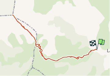
Trail Walking of 12.6 km to be discovered at Provence-Alpes-Côte d'Azur, Hautes-Alpes, Le Dévoluy. This trail is proposed by Dervalmarc.
Description
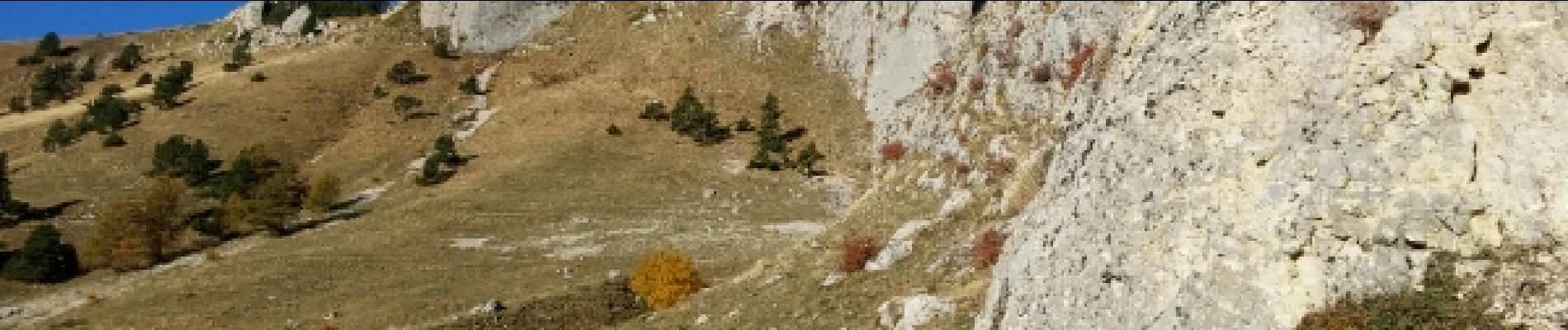
Randonnée vertigineuse après le col de Plate Contier.Deux passages délicats entre le Pas de l'Agneau et la Cime.Superbe vue panoramique sur tout le Devoluy.Efforts soutenus jusqu'à la Cime.
Positioning
Country:
France
Region :
Provence-Alpes-Côte d'Azur
Department/Province :
Hautes-Alpes
Municipality :
Le Dévoluy
Location:
Unknown
Start:(Dec)
Start:(UTM)
725079 ; 4946903 (31T) N.
Comments
Trails nearby
![Trail Walking Le Dévoluy - R13 Le Col de Lauteret - Photo](https://media.geolcdn.com/t/375/260/ext.jpg?maxdim=2&url=https%3A%2F%2Fservices.sitytrail.com%2FGeolivesWS%2FDownloadMedia.ashx%3FTrailID%3D890869%26Media%3D3ddec85f-ff9e-4fa0-b708-df941654a773.jpg)
![Walking Walking](https://static1.geolcdn.com/sitytour/trail-icons/101.png)
R13 Le Col de Lauteret
Walking
Medium
(1)
Le Dévoluy,
Provence-Alpes-Côte d'Azur,
Hautes-Alpes,
France
![](/images/other/stat-length.png)
8.5 km | 15.9 km-effort
3h 12min
![](https://static1.geolcdn.com/siteimages/upload/files/16400158638029165_repeat_loop_refresh_sync_direction_icon.png)
Yes
![Trail Walking Le Dévoluy - R12 Le Col des Aiguilles - Photo](https://media.geolcdn.com/t/375/260/ext.jpg?maxdim=2&url=https%3A%2F%2Fservices.sitytrail.com%2FGeolivesWS%2FDownloadMedia.ashx%3FTrailID%3D890868%26Media%3Da17a685b-d707-4ec8-9ad3-ca551d593978.jpg)
![Walking Walking](https://static1.geolcdn.com/sitytour/trail-icons/101.png)
R12 Le Col des Aiguilles
Walking
Medium
(1)
Le Dévoluy,
Provence-Alpes-Côte d'Azur,
Hautes-Alpes,
France
![](/images/other/stat-length.png)
10.2 km | 19.2 km-effort
3h 56min
![](https://static1.geolcdn.com/siteimages/upload/files/16400158638029165_repeat_loop_refresh_sync_direction_icon.png)
Yes
![Trail Walking Le Dévoluy - R11 Cabane Rama - Photo](https://media.geolcdn.com/t/375/260/ext.jpg?maxdim=2&url=https%3A%2F%2Fservices.sitytrail.com%2FGeolivesWS%2FDownloadMedia.ashx%3FTrailID%3D890866%26Media%3D15965f3b-d395-4eb7-8005-d43c93878ecf.jpg)
![Walking Walking](https://static1.geolcdn.com/sitytour/trail-icons/101.png)
R11 Cabane Rama
Walking
Very easy
(4)
Le Dévoluy,
Provence-Alpes-Côte d'Azur,
Hautes-Alpes,
France
![](/images/other/stat-length.png)
5.5 km | 8.4 km-effort
1h 46min
![](https://static1.geolcdn.com/siteimages/upload/files/16400158638029165_repeat_loop_refresh_sync_direction_icon.png)
Yes
![Trail Walking Le Dévoluy - Cascade de Saute Aure - Photo](https://media.geolcdn.com/t/375/260/ext.jpg?maxdim=2&url=https%3A%2F%2Fservices.sitytrail.com%2FGeolivesWS%2FDownloadMedia.ashx%3FTrailID%3D206042%26Media%3Dfix__20130719142756.jpg)
![Walking Walking](https://static1.geolcdn.com/sitytour/trail-icons/101.png)
Cascade de Saute Aure
Walking
Easy
(3)
Le Dévoluy,
Provence-Alpes-Côte d'Azur,
Hautes-Alpes,
France
![](/images/other/stat-length.png)
7.7 km | 10.8 km-effort
3h 1min
![](https://static1.geolcdn.com/siteimages/upload/files/16400158638029165_repeat_loop_refresh_sync_direction_icon.png)
Yes
![Trail Walking Le Dévoluy - suuntoapp-Hiking-2024-06-17T07-23-45Z - Photo](https://media.geolcdn.com/t/375/260/1d5aff52-7442-421b-9399-0de1c57b8c1c.jpg&format=jpg&maxdim=2)
![Walking Walking](https://static1.geolcdn.com/sitytour/trail-icons/101.png)
suuntoapp-Hiking-2024-06-17T07-23-45Z
Walking
Difficult
Le Dévoluy,
Provence-Alpes-Côte d'Azur,
Hautes-Alpes,
France
![](/images/other/stat-length.png)
9.6 km | 17.9 km-effort
4h 4min
![](https://static1.geolcdn.com/siteimages/upload/files/16400158638029165_repeat_loop_refresh_sync_direction_icon.png)
Yes
![Trail Walking Le Dévoluy - Tête de Garnesier - Photo](https://media.geolcdn.com/t/375/260/36fc5862-5393-4842-9373-0faa5a8d0520.jpg&format=jpg&maxdim=2)
![Walking Walking](https://static1.geolcdn.com/sitytour/trail-icons/101.png)
Tête de Garnesier
Walking
Very difficult
Le Dévoluy,
Provence-Alpes-Côte d'Azur,
Hautes-Alpes,
France
![](/images/other/stat-length.png)
11.5 km | 26 km-effort
5h 57min
![](https://static1.geolcdn.com/siteimages/upload/files/16400158638029165_repeat_loop_refresh_sync_direction_icon.png)
Yes
![Trail Walking Le Dévoluy - Maniboux - Photo](https://media.geolcdn.com/t/375/260/b32795f5-575c-433e-a782-ea2573efdabc.jpg&format=jpg&maxdim=2)
![Walking Walking](https://static1.geolcdn.com/sitytour/trail-icons/101.png)
Maniboux
Walking
Medium
Le Dévoluy,
Provence-Alpes-Côte d'Azur,
Hautes-Alpes,
France
![](/images/other/stat-length.png)
10.9 km | 16.9 km-effort
3h 49min
![](https://static1.geolcdn.com/siteimages/upload/files/16400158638029165_repeat_loop_refresh_sync_direction_icon.png)
Yes
![Trail Walking Le Dévoluy - Col des Aiguilles - Photo](https://media.geolcdn.com/t/375/260/8a911a3c-01ba-4879-b0c6-2fd186c02efb.jpg&format=jpg&maxdim=2)
![Walking Walking](https://static1.geolcdn.com/sitytour/trail-icons/101.png)
Col des Aiguilles
Walking
Difficult
Le Dévoluy,
Provence-Alpes-Côte d'Azur,
Hautes-Alpes,
France
![](/images/other/stat-length.png)
11.3 km | 21 km-effort
4h 46min
![](https://static1.geolcdn.com/siteimages/upload/files/16400158638029165_repeat_loop_refresh_sync_direction_icon.png)
Yes
![Trail Walking Le Dévoluy - Cabane de la Rama - Photo](https://media.geolcdn.com/t/375/260/64d68da8-e0f7-42f5-a12c-f9139da8a866.jpg&format=jpg&maxdim=2)
![Walking Walking](https://static1.geolcdn.com/sitytour/trail-icons/101.png)
Cabane de la Rama
Walking
Easy
Le Dévoluy,
Provence-Alpes-Côte d'Azur,
Hautes-Alpes,
France
![](/images/other/stat-length.png)
5.8 km | 8.6 km-effort
1h 56min
![](https://static1.geolcdn.com/siteimages/upload/files/16400158638029165_repeat_loop_refresh_sync_direction_icon.png)
Yes